• Register
  • Log in
  • Home
  • Company Profile
  • Projects
  • Services
  • Event
  • GIS Datasets
  • Equipments/Instrumentation
  • Partners
  • Contact
  • CHC NAV
    >
  • SpaceMouse®
  • TOPCON
    >
  • Survey & Engineering
  • GNSS Infrastructure
  • Marine Construction
  • GIS Data Collection
  • 3D Laser Scanner GLS-1500
  • 3D Laser Scanner GLS-2000

  • Projects
  • Services
  • Digital Utilities
    >
  • Business Intelligence
  • IOT:Smart Home & Work Space
  • SCADA
  • Roads & Highways
  • Railway
  • Oil & Gas
  • Mineral Resources
  • Training
    >
  • Maintenance and Support
  • Electricity
  • Water
  • Gas
  • National
  • Overseas

Sampling Technique

Sampling The determination of sample size for processes is concerned with the following issues under the assumption that the characteristic of the population were more or less homogenous.

  •  The definition of the population
  • The creation of sampling frame
  • The choice of Probability versus Non-probability sampling
  • The calculation of sample size

The creation of sampling frame: The standard rule for sampling frame has been followed based on SRS (Simple Random Sampling). The choice of Probability versus Non-probability sampling: Probability sampling has been followed.

The calculation of sample size: To determine the minimum sample size the following formula has been followed:
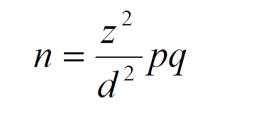
Where

  • n=sample
  • size z= statistical certainty chosen
  • p= coverage rate/estimated prevalence q=1-p and
  • d= precision desired

Sample Size Calculator

Calculate Your Sample Size:


The total number of people whose opinion or behavior your sample will represent.


The probability that your sample accurately reflects the attitudes of your population. The industry standard is 95%.


The range (measured as a percentage) that your population’s responses may deviate from your sample’s.

Sample Size

*This sample size calculator uses a normal distribution (50%) to calculate your optimum sample size.

  • Services
  • Power  Engineering 
  • Power Distribution  Planning
  • URBAN DESIGN + PLANNING
  • Education
  • Monitoring & Evaluation
  • Crash/Injury Data
  • Climate Change & Environment
  •  
  • Irrigation Management
  • Surface Water
  • Geotechnical Assesment
  • Forestry
  • Land Management
  • Transport Planning
  • Disaster Management
  •  
  • Statistical Data Analysis
  • Photogrammetry
  • Ground Water Modeling
  • Urban Revenue Enhancement
  • Hydrographic Survey
  • LiDAR Data Processing
  • Rural Development
  • Services
  • Power  Engineering 
  • Power Distribution  Planning
  • URBAN DESIGN + PLANNING
  • Education
  • Monitoring & Evaluation
  • Crash/Injury Data
  • Climate Change & Environment
  •  
  • Irrigation Management
  • Surface Water
  • Geotechnical and Geophysical Assesment
  • Forestry
  • Land Management
  • Transport Planning
  • Disaster Management
  •  
  • Statistical Data Analysis
  • Photogrammetry
  • Ground Water Modeling
  • Urban Revenue Enhancement
  • Hydrographic Survey
  • LiDAR Data Processing
  • Rural Development
 
     
BIN: 001124105, Trade License No. 79089, Company Documents 2019-20,SOB Survey Approval Certificate

© 2025 - Copyright© 2005 - 2021 Arc Bangladesh Ltd. � Geospatial Information | Software Development | Engineering Consultancy